The first visit I made to the Maya ruins in Caracol, Belize, involved a three-hour trip through a labyrinth of deeply potholed dirt roads, in a vehicle helmed by a steel-nerved driver. I spent the ride crouched in the back, trying to ignore the potentially tire-busting jolts.
So it seemed like a miracle when I returned just a year later, in the spring of 2026, and found a newly completed highway leading smoothly through the fragrant Mountain Pine Ridge Forest Reserve, past a smattering of logging towns, and into the Chiquibul rainforest, a lush jungle landscape alive with butterflies and songbirds.
When I arrived at the Caracol field camp, I was greeted by Arlen and Diane Chase , both archaeologists at the University of Houston , where Diane also serves as provost. Joining them was their 35-year-old son, Adrian Chase , who is also an archaeologist and currently a postdoctoral fellow at Tulane University’s Middle American Research Institute . Their camp is a semicircle of zinc-roofed, thatch-sided shacks with no running water, no cellphone reception and fickle electrical service. The students, volunteers and staff who eat, sleep, work and occasionally play here are issued a water jug, a hammock and a machete. When I asked about the latter, Adrian cheerfully explained that he had used his that very morning to behead a fer-de-lance pit viper . “We don’t have antivenom and we’re miles from a clinic, so a bite from that snake is pretty much a death sentence,” he told me, with a hint of mischief.
Archaeologists once considered Caracol a minor site barely worth their time, but its remoteness turned out to be an asset. Other Maya strongholds like Tikal in Guatemala and Chichén Itzá in Mexico were first encountered by European colonists in the 19th century. Caracol, hidden in dense tropical forest, had barely been excavated when the Chases arrived in the 1980s. Over the following decades their painstaking work exploded a number of misleading myths about the Maya.
For centuries, most scholarly assumptions about this ancient civilization came from the writings of Friar Diego de Landa , a 16th-century Spaniard who lived as a missionary among the Maya communities in the Yucatán. By his own account, de Landa burned most of the Maya’s hieroglyphic codices. “These people also used certain characters or letters, with which they wrote in their books about the antiquities and their sciences,” de Landa wrote in Yucatán Before and After the Conquest . “We found a great number of books in these letters, and since they contained nothing but superstitions and falsehoods of the devil, we burned them all, which they took most grievously, and which gave them great pain.” As American scholar William Gates wrote, introducing his English translation of de Landa’s writings, the bishop “burned 99 times as much knowledge of Maya history and sciences as he has given us.”
Subscribe to Smithsonian magazine now for just $19.99
This article is a selection from the November 2026 issue of Smithsonian magazine
De Landa falsely portrayed the Maya as largely an impoverished rural peasantry lorded over by a ruthless aristocracy who dwelled in monumental cities. “The Spanish imposed their worldview on everything over here,” Arlen said. “And if you look back at Spain in the 1500s, what are you dealing with? You had knights and nobles in castles, and everyone else was scattered throughout the countryside. The Spaniards slapped that two-class model onto the Maya.”
By the time Arlen and Diane were in graduate school at the University of Pennsylvania in the 1970s, more was known about the ancient culture—for instance, that the Maya had designed one of the world’s most sophisticated calendars and held a deep understanding of astronomy, mathematics and architecture. But most scholars saw the Maya as peaceful stargazers so absorbed by gauzy ceremonial pursuits that they neglected certain practical concerns. In the influential 1954 book The Rise and Fall of Maya Civilization , British archaeologist J. Eric S. Thompson wondered how the Maya were able to “chart the heavens yet fail to grasp the principle of the wheel; to visualize eternity as no other semi-civilized people has ever done, yet ignore the short step from corbeled to true arch; to count in millions yet never learn to weigh a sack of corn.” Anthropologists believed that Maya cities had been near-empty husks, with a dispersed, rural population who ventured into town only for occasional ceremonies, or to serve elites.
Arlen and Diane challenged this conventional wisdom. In 1979, four years after they were married, they set off for a six-year stint at Santa Rita Corozal, a Maya site in Belize just south of the Mexican border. As they excavated residential areas, they found that many non-elites had owned tools made of obsidian, a dark, glassy stone found only in distant volcanic regions. Scholars at the time assumed that Maya elites had total control over ancient economies and distributed goods directly to specific people. But the sheer number of non-elites in Santa Rita who had this imported material made it unlikely that elites were bestowing obsidian directly to those households as gifts or rewards. A more plausible explanation was that Santa Rita was an important trading junction, between the coastline and two rivers, and that residents had market access to imported goods like obsidian, jade, ceramics and shells.
Santa Rita, though rich in history, had its limitations. Much of the ancient city had been bulldozed by development or lay buried under modern buildings. So the Chases set their sights on the largely untouched site of Caracol, deep in the rainforest about 180 miles south. Arriving in 1987, Diane recalled, “We found no visible temples, no architecture. We pretty much had the place to ourselves. Our colleagues thought we were crazy.”
But the Chases and their team have shown that far from being a ceremonial husk, Caracol had a peak population of more than 100,000. (By comparison, Belize City, the largest urban area in the nation today, has a population around 66,000.) Uncovering actual evidence of how residents of this vast metropolis lived, Arlen said, “meant going against the anthropological concepts of the day. So everything you were taught in grad school—you find out it isn’t right.”
The Chases felt fortunate that the Spaniards never reached the ruins of Caracol. Nor did many other people. In fact, the site had been all but lost to history when a lumberman stumbled upon it in 1937 and noticed strange swellings in the verdant landscape. A year later, A.H. Anderson, the archaeological commissioner of what was then called British Honduras (now Belize), braved a several-day slog on muleback to see the ruins for himself. He named the site “Caracol,” the Spanish word for snail, a reference both to the plentiful shell fragments littering the site and the nearly impassable nautilus of overgrown track leading to it. Anderson unearthed 11 monuments, several of them carved with Mayan hieroglyphics. Lacking the resources and expertise to continue, he spent the next decade trying to lure a team of better-financed investigators to join him.
Linton Satterthwaite, a Maya specialist from the University of Pennsylvania, arrived at Caracol in the 1950s and excavated 20 tons of mostly fragmented limestone monuments over three seasons. Among the finds were 35 ceramic vessels and stone slabs engraved with hieroglyphics. Years later, on one of their first dates, Arlen and Diane saw a collection of these relics at the university’s Museum of Archaeology and Anthropology, better known as the Penn Museum. The university’s link with ancient Maya culture set their own careers in motion. As they went on to teach at a number of institutions, Caracol remained their enduring passion.
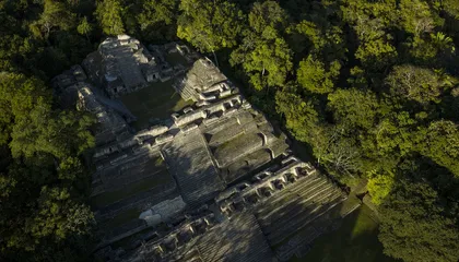
As you walk through Caracol today, the most striking feature is Caana, a 141-foot-high “sky palace” that was abandoned around the year 900, at the tail end of the Maya Classic era. Caana is still the tallest construction in Belize. Yet when the Chases arrived in the 1980s, the massive, multitiered complex was an enormous mound mostly covered in jungle overgrowth. Satterthwaite did some initial mapping of the structure, but the Chases meticulously cleared the vegetation, opening long-sealed passageways and excavating the rooms and stairwells. The complex was built in the triadic style, with a main temple at the rear of the top terrace and two smaller temples facing each other at its flanks, all surrounding a central, elevated plaza. I found it beyond belief that this magnificent temple was erected without the aid of the wheel, metal tools or a single beast of burden. Climbing to the top, I was rewarded with a sweeping view of the surrounding Chiquibul Forest Reserve , with undulating, tree-covered hills stretching toward the Maya Mountains. Exotic bird sightings here might include king vultures, woodcreepers, toucans, parrots and—for the very lucky—the resplendent scarlet macaw. The roars of howler monkeys seem to come straight from the Jurassic Park soundtrack, and spider monkeys swing through the treetops like arboreal acrobats.
Caracol’s buildings were clearly meant to be admired from outside. Some of the pyramid temples even doubled as astronomical observatories, where elites tracked the movements of Venus and other heavenly bodies. But the interior space at Caana was also carefully designed. Rooms with C-shaped stone benches were most likely formal meeting spaces, while L-shaped benches were most likely used for sleeping. The walls were bedecked in white stucco and red paint. I found Caana’s broad limestone stairway steep to the edge of treacherous, and I shuddered to imagine young Maya children making the climb. I was told they were carried by servants, but that, too, seemed perilous.
Fun facts: More to know about Caracol
Caracol’s road network was once part of a much larger Maya transportation system.
The lidar work in Caracol helped inspire similar studies of Maya sites in Guatemala.
Work in Caracol helped reveal the extent of Maya wars and rivalries.
Caana is the most iconic relic at Caracol, but it may not be the most important. In the late winter of 1986, Arlen was slashing through the brush of an overgrown Maya ball court when his machete struck something solid. The object turned out to be a large limestone disk incised with concentric rings of Mayan hieroglyphics.
The disk was eroded, but half the glyphs were still legible. Epigraphers found a reference to Caracol Lord K’an II and his A.D. 631 war against the city-state of Naranjo . Scholars call such conflicts “star wars” because the Maya noted them with a glyph of an ascendant star. These bloody battles not only diminished the losing state’s prestige and power, but also threatened its economy by slaughtering its rulers and conscripting its soldiers into slavery. The glyphs highlighted K’an II’s father, Yajaw Te’ K’inich II, and his defeat of the kingdom of Tikal, roughly 50 miles to the northwest.
The very notion that a presumed pipsqueak like Caracol had defeated mighty Tikal struck many scholars as a far-fetched David-and-Goliath story. “No one believed us,” Diane said. “Some people thought we carved the glyphs ourselves.” But newer evidence pointed to a period spanning from 557 to 682, a tumultuous time when Tikal’s monuments were neglected, suggesting a decline in population and prestige. And as Tikal declined, Caracol rose dramatically in population and power, as evidenced by a boom in new construction and infrastructure throughout the city. The Chases noted that these shifts in fortune coincided with the star war described in the glyphs. “When a state wins a war, it grows in population and prosperity,” Diane told me. “When it loses a war, it declines.” Which suggested that Caracol, not Tikal, had won.
The Chases’ theory of Caracol’s victory over Tikal was bolstered by further excavations, surveys, epigraphy, and isotope analyses of bones and other organic material. “Caracol dominated Tikal and Naranjo for roughly 140 years,” Arlen said. “During that period, it replaced Tikal as the major regional power.” While this version of history was once hard for traditionalists to accept, the Chases’ further discoveries made it all but undeniable. I was eager to see some of them.
During my visit to the field camp, Diane guided me to a large, ramshackle structure known as the “laboratory”: a jumble of books, odd pieces of equipment and overflowing suitcases flanked by a well-stocked meat freezer powered by a recently installed solar array. A diaphanous curtain shielded what passed for a “bedroom” from a pair of plywood worktables littered with water bottles, coffee mugs and hundreds of clay shards. I watched as Arlen reassembled the shards into vessels, holding the bits and pieces in place with wooden clothespins as the glue dried. Nearby, Diane examined, identified and tagged bone fragments as Adrian demonstrated a handheld scanner used to locate and map the ruins.
For nearly 25 years, Arlen mapped Caracol by foot, crashing through the jungle with surveying equipment slung over his shoulder. His team uncovered vaulted passageways, secret corridors, sacred altars, and caches of pottery and elaborate jewelry. As in Santa Rita, they found that non-elites in Caracol had wide access to obsidian.
Both Diane and Arlen kept meticulous records of everything they found, with Diane especially focusing on skeletal material and Arlen on ceramics. The process was arduous and achingly slow, and they managed to cover only a fraction of the city. But in 2009, their team became the first in Mesoamerica to make full use of light detection and ranging, or lidar , a highly sensitive instrument that deploys thousands of laser beams to look beneath the jungle canopy.
“Before the lidar study, we had no idea how big Maya cities were,” Arlen explained. “Everything was still conceptualized as small cities with central architecture and rural settlement around the larger architecture.” The imaging shifted the picture. “We could see all of the terraces. We could see all the residential groups, all the road systems. We could see looters’ trenches and looted tombs.”
The Chases have estimated that Caracol had around 36,000 structures, as well as causeways covering an astonishing 77 square miles. The densely populated megacity had its own civic infrastructure, including a road system, terraced farms and about 1,600 reservoirs. The temples, ball courts, arcropolises and plazas were all linked by broad limestone-paved avenues. Residential units were grouped in tight-knit neighborhoods of roughly 250 to 300 people.
A major revelation was that almost all the city’s residents lived within a 20-minute walk of a marketplace. Caracol was what realtors today would call a “walkable city,” with residential neighborhoods close to markets that the Chases describe as “strip malls.” The Chases’